 |
|
|
 |
|
 |
|
THE GEOGRAPHY OF THE NILE VALLEY
|
|
 |
THE NILE RIVER
|
 |
|
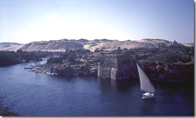 |
To understand the Nile River is to understand Egypt. It defines the
nation in every way.
Ancient Egypt traditionally ran from the First Cataract of the river
over 600 miles north to the Mediterranean Sea. On average the Valley
is only twelve miles wide -- a strip of fertile land between inhospitable
deserts.
As the Sahara grew hot, the ancestors of the ancient Egyptians drifted
to the river, clan by clan, tribe by tribe. They lined the river like
beads on a necklace.
|
|
Year after year the Nile flooded,
depositing nutrient-rich black mud along its banks. Crops and villages
flourished, creating all the ingredients needed to support life and
the growth of a great civilization. The ancient Egyptians called their
country Kemet, the "Black Land" after this Nile mud.
Everywhere else was desert wasteland: Deshret, the "Red
Land".
|
|
The Nile forms a highway linking
every city and village on the river to every other. It gave the pharaohs
a unique ability to unify the nation. The power of the 'Sons of Ra'
could be everywhere along the Nile.
Unified by the river and bounded by desert and sea, ancient Egypt was
protected from outside influences and allowed to evolve in its own unique
way.
The Nile River permitted -- one could even say demanded --
the rise of Egyptian Civilization.
|
 |
|
The Egyptians settled along
the Nile in three main clusters:
UPPER EGYPT
Mostly between Thebes and the First
Cataract. The ancient Egyptians made the lowlands along the upper
reaches of the Nile fit for cultivation. They cut the earthen banks
of the river to allow the annual flood waters
to fill huge irrigation basins.
This required cooperation on a scale beyond single villages and provoked
the political growth of the Upper Egyptian
state.
THE FAIYUM
Lake Moeris in the Faiyum region is a natural oasis irrigated by a run-off
branch of the Nile. The pharaohs of the Middle
Kingdom reclaimed large tracts of land from around the lake and
put them under cultivation. Under the Ptolemies in the Greco-Roman
Period the Greeks settled here in large numbers, preferring it to
other stretches of the Nile Valley.
THE DELTA - LOWER EGYPT
The Delta has always been for the most part a huge swamp laced with
waterways. Few areas remain above the water during the Nile flood. Tidal
surges wash into the marshes along the Mediterranean coast. The Egyptians
have labored for millenia to maintain their settlements, dams and drainage
canals. Despite the difficulties, the majority of the Egyptian population
has always in Lower Egypt (although much of what they built is now
lost).
|
|
Home
| Nile Valley | Dynasties
| Wealth | Divinity
| Temples | Hieroglyphs
| Mysteries
|
|
| |
|
|
|
|
|
|